New Zealand Topo Maps✓
- Name :
- New Zealand Topo Maps
- Category:
- Maps & Navigation
- Safety :
- 100% Safe
- Price:
- free
- Developer:
- ATLOGIS Geoinformatics GmbH & Co. KG
- Download :
- 100K+
Screenshot


App Intro
Navigating New Zealand's diverse landscapes, from rugged mountains to coastal trails, just got significantly easier with this intuitive outdoor navigation app. It brings the power of professional-grade GPS devices right to your smartphone, offering detailed topographic maps of New Zealand, the Cook Islands, and Tokelau. Whether you're a seasoned tramper, a keen cyclist, or planning an off-road adventure, this app is designed to be your reliable companion. It provides essential tools for creating waypoints, recording tracks with detailed metrics like speed and elevation, and navigating directly to your desired points. The ability to import and export GPX files adds flexibility for planning routes elsewhere and integrating with other devices. With various map layers available, including official LINZ topographic maps and nautical charts, you can customize your view for any activity. It’s an indispensable tool for anyone venturing into areas where cell service is unreliable, with the Pro version offering offline search capabilities.
Feature Guides
- Create, edit, and navigate to custom waypoints with ease, marking important locations like campsites or viewpoints.
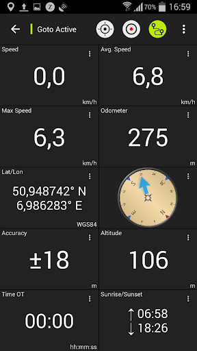
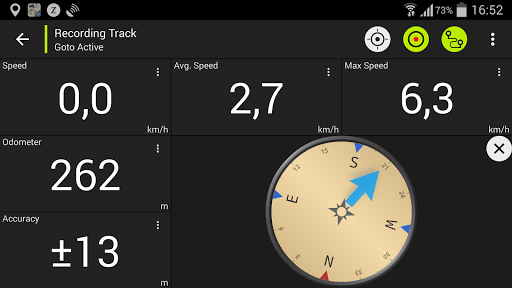
- Record your journeys with detailed track data, including speed, elevation changes, and accuracy, to analyze your performance or share your routes.
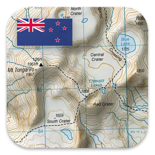
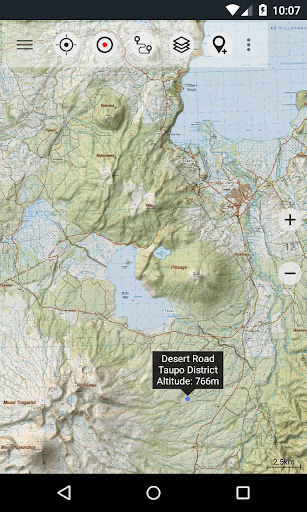
- Access a comprehensive suite of mapping options, from detailed 1:50,000 topographic maps of New Zealand to nautical charts and satellite imagery, with overlay options for conservation areas and huts.
- Utilize advanced navigation features such as a Tripmaster for real-time trip data and the ability to use coordinates in UTM, WGS84, or MGRS formats, catering to serious outdoor enthusiasts.
- Seamlessly share your waypoints, tracks, and routes with friends or fellow adventurers via email or social media platforms.
Recent Improvements
Recent updates have focused on enhancing the user experience with refined map rendering for better clarity, especially at higher zoom levels. Performance optimizations have been implemented to ensure smoother track recording and navigation, even in areas with limited processing power. We've also improved the stability of waypoint and track management, making it more reliable to save and access your data. Feedback from users has guided subtle but important tweaks to the interface, aiming for a more streamlined interaction when setting up navigation or customizing data fields. These refinements contribute to a more robust and user-friendly experience for all your outdoor expeditions.
FAQ
Can I use this app without an internet connection?
Yes, absolutely! A key feature is the ability to download map data for offline use, which is crucial for areas with no cell service. This allows you to use all navigation functions, including viewing topographic maps, creating waypoints, and recording tracks, even when you're completely off the grid.
What's the difference between the free and Pro versions?
The free version is great for trying out the app's core features but has limitations like ads, a maximum of 3 waypoints and tracks, and no route functionality. The Pro version removes ads, lifts waypoint and track limits, enables route creation and import/export, and offers bulk map downloads for extensive offline use.
Are the topographic maps accurate enough for serious hiking?
The app utilizes official Topo50 maps from Land Information New Zealand (LINZ), which are the same maps used by emergency services. These maps offer detailed 1:50,000 scale coverage, providing high accuracy for terrain features, tracks, and points of interest, making them suitable for serious hiking and backcountry navigation.
Editor Security Review
Reviewed by the editorial team for
basic security, integrity, and package consistency checks.
- No known malware detected
- Signature verified
- File integrity checked
User reviews
This app has been a game-changer for my tramping trips in the Kaweka Forest Park! The offline maps are incredibly detailed and accurate. Finally, a reliable GPS app for NZ that doesn't rely on cell signal. ⛰️
Used it for a multi-day bike tour on the West Coast. Being able to record my tracks and export them later was super handy. The different map layers are a great touch for planning where to explore next. 👍
 ParkiMaps & Navigation
 MyTranslinkMaps & Navigation
 13cabs - Ride with no surgeMaps & Navigation
 CabifyMaps & Navigation
 Careem – rides, food & moreMaps & Navigation
 CitymapperMaps & Navigation
 ChargePointMaps & Navigation
 Electrify AmericaMaps & Navigation
 MapQuest: Get DirectionsMaps & Navigation
 MarineTraffic - Ship TrackingMaps & Navigation
 네이버지도 (Naver Map)Maps & Navigation
 NJ TRANSIT Mobile AppMaps & Navigation
 ParkableMaps & Navigation
 Park ATXMaps & Navigation
 REVER - Motorcycle GPS & RidesMaps & Navigation
 Roadie DriverMaps & Navigation
 GPS EmulatorMaps & Navigation
 MyBluebirdMaps & Navigation
 Location ShareMaps & Navigation
 Trucker Path: Truck GPS & FuelMaps & Navigation