
MarineTraffic - Ship Tracking✓
- Name :
- MarineTraffic - Ship Tracking
- Category:
- Maps & Navigation
- Safety :
- 100% Safe
- Price:
- free
- Developer:
- MarineTraffic Applications
- Download :
- 5M+
Screenshot
App Intro
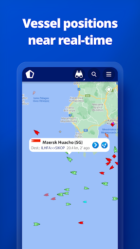
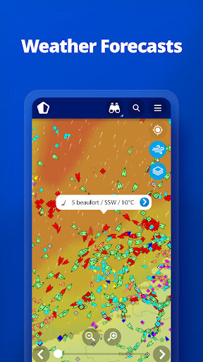
MarineTraffic is an indispensable tool for anyone interested in maritime activity, offering near real-time tracking of ships and yachts across the globe. Leveraging an extensive network of land-based Automatic Identification System (AIS) receivers, it provides comprehensive coverage for most major ports and shipping lanes. Whether you're a professional mariner, a shipping enthusiast, or simply curious about the vessels around you, MarineTraffic brings the world's waterways to your fingertips. The app's live map displays vessel positions, allows for detailed searches, and even shows what's in your vicinity. With over 300,000 vessels reporting their positions daily, it's a dynamic and constantly updated resource. Its utility extends to providing live port arrivals and departures, wind data, and historical track playback, making it a valuable asset for planning and information gathering. The ability to manage your fleet across devices and browse millions of photos adds further depth to the user experience, making it a highly recommended download for a wide audience.
Feature Guides
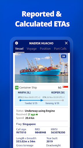
- Explore the live map to view the real-time positions of vessels worldwide. You can search for specific ships, boats, and even seaports, and discover what's currently near your location.
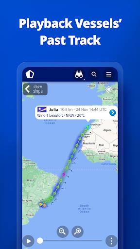
- Access detailed vessel information, including live wind data and a 48-hour wind forecast displayed directly on the map. Visualize vessel movements with animated playback of their tracks.
- Stay updated with live port arrivals and departures for over 4,000 ports and marinas, complete with current conditions and estimated times of arrival for ships.
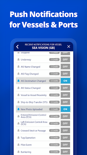
- Personalize your experience by managing your fleet within the 'MY FLEET' section, which synchronizes seamlessly with MarineTraffic.com across all your devices.
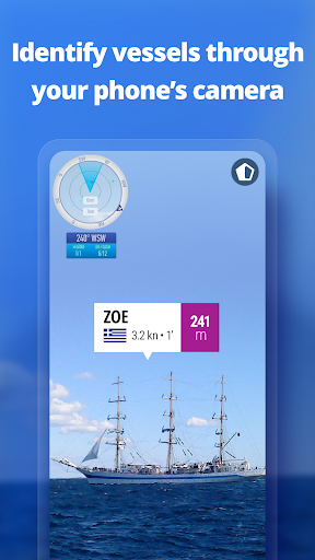
- Utilize the Augmented Reality tool to identify vessels around you by simply pointing your device's camera towards the horizon, instantly revealing crucial details like name, flag, and speed.
Recent Improvements
Recent updates have focused on enhancing the fluidity of map interactions and refining the accuracy of vessel data acquisition. Users will notice smoother transitions when zooming and panning across the live map, ensuring a more responsive experience. We've also made significant strides in optimizing the data feed, leading to more timely updates on vessel positions and port activities. The integration of enhanced weather layers has also been a priority, providing clearer and more detailed meteorological information for marine planning. These refinements aim to provide a more seamless and informative maritime tracking experience for all users.
FAQ
How accurate is the real-time vessel tracking?
MarineTraffic relies on the Automatic Identification System (AIS) network, which is the primary source for vessel positions. While highly accurate, the 'near real-time' nature means there can be slight delays, typically a few seconds to a minute, depending on network conditions and vessel equipment. The density of land-based receivers also influences coverage, with major shipping lanes and ports having the most up-to-date information.
Can I track vessels outside of coastal areas or where land-based receivers are scarce?
Yes, for users who need to track vessels beyond the range of our extensive land-based AIS network, MarineTraffic offers satellite tracking capabilities through the ACCESS PLUS 24 service, available as an in-app purchase. This extended coverage ensures you can monitor ships even in open ocean environments.
Is MarineTraffic suitable for professional use, like for shipping companies?
Absolutely. MarineTraffic is widely used by professionals in the maritime industry. Its comprehensive features, including live tracking, port data, fleet management, and advanced features for subscribers like nautical charts and SAT-AIS data, make it an invaluable tool for ship owners, operators, charterers, and logistics managers seeking operational insights and efficiency.
Editor Security Review
Reviewed by the editorial team for
basic security, integrity, and package consistency checks.
- No known malware detected
- Signature verified
- File integrity checked
User reviews
This app is an absolute game-changer for my hobby of ship spotting! 🚢 The live map is incredibly detailed and the augmented reality feature is just mind-blowing when I'm down at the docks. Highly recommend!
As someone working in logistics, MarineTraffic has become my go-to tool. The port arrival/departure information is usually spot-on, and I love being able to track my company's fleet easily. The satellite tracking add-on is worth every penny for our overseas operations. ⚓
 ParkiMaps & Navigation
 MyTranslinkMaps & Navigation
 New Zealand Topo MapsMaps & Navigation
 13cabs - Ride with no surgeMaps & Navigation
 CabifyMaps & Navigation
 Careem – rides, food & moreMaps & Navigation
 CitymapperMaps & Navigation
 ChargePointMaps & Navigation
 Electrify AmericaMaps & Navigation
 MapQuest: Get DirectionsMaps & Navigation
 네이버지도 (Naver Map)Maps & Navigation
 NJ TRANSIT Mobile AppMaps & Navigation
 ParkableMaps & Navigation
 Park ATXMaps & Navigation
 REVER - Motorcycle GPS & RidesMaps & Navigation
 Roadie DriverMaps & Navigation
 GPS EmulatorMaps & Navigation
 MyBluebirdMaps & Navigation
 Location ShareMaps & Navigation
 Trucker Path: Truck GPS & FuelMaps & Navigation