US Public Lands✓
- Name :
- US Public Lands
- Category:
- Travel & Local
- Safety :
- 100% Safe
- Price:
- 3.99
- Developer:
- Two Steps Beyond LLC
- Download :
- 10K+
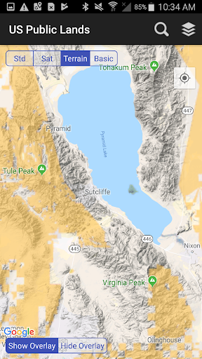
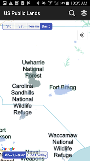
Screenshot

App Intro
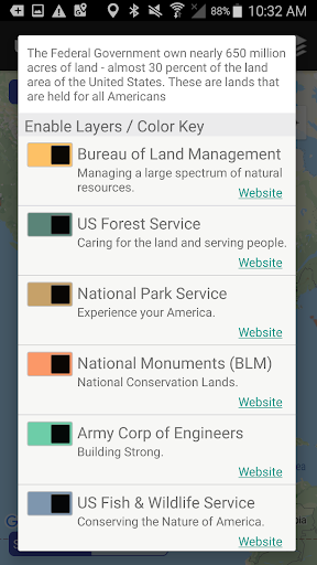
Navigating the vast expanse of U.S. federal lands can be a daunting task, but the US Public Lands app aims to simplify this process. This application provides on-device, offline access to boundary data for nearly 650 million acres of land managed by various federal agencies. Whether you're a hiker, hunter, boondocker, or simply curious about the land around you, this app offers a convenient way to identify federal property and the managing agency. It's an invaluable tool for anyone who spends time outdoors and wants to understand land ownership, making it a worthwhile download for outdoor enthusiasts and explorers alike. The app empowers users to make informed decisions about land use and activities.
Feature Guides
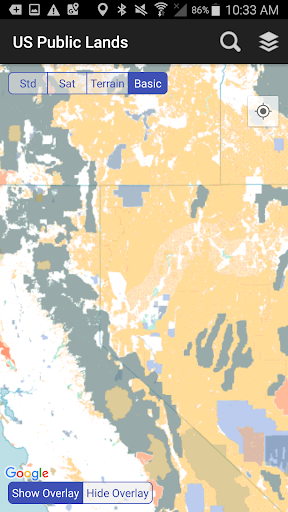
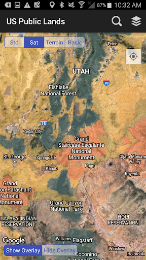
- Visualize federal land boundaries from agencies like the BLM, Forest Service, NPS, and more, all color-coded for easy identification directly on your map.
- Access detailed information and links to each agency's website for specific land use rules, permits, and regulations, ensuring you're always compliant.
- Enjoy full offline functionality; all map layers and base maps are stored on your device, eliminating the need for an internet connection and saving data.
- Utilize the 'Locate Me' feature with GPS to instantly see your position on the map and determine the type of land you are currently on. 🗺️
- Seamlessly switch between basic, standard, and satellite map views to get the best perspective for scouting trails or identifying dispersed camping opportunities.
Recent Improvements
Recent updates have focused on enhancing the precision and usability of the federal land boundary data. We've refined the layer rendering for a smoother visual experience and improved the responsiveness of the map controls. Additionally, the internal links to agency resources have been reviewed and updated to ensure users can easily access the most current information regarding land use policies and regulations. These refinements aim to make your exploration of public lands more informed and enjoyable.
FAQ
Can I use this app without an internet connection?
Yes! A key feature of US Public Lands is its robust offline capability. All essential map layers, including federal land boundaries and basic base maps, are stored directly on your device. This means you can access and use the app's core features even in areas with no cell service or Wi-Fi.
How accurate are the land boundaries shown in the app?
The maps are generated from the U.S. Geological Survey's Protected Area Database (PAD-US), which is the most comprehensive aggregation of federal lands available. However, this data is continuously evolving, and some boundaries may have variations in precision or may not be listed. Always cross-reference with local signage and official resources for critical decisions.
Does the app show specific campsites or points of interest?
US Public Lands primarily focuses on displaying the boundaries of federal lands and the agencies that manage them. While it's a fantastic tool for identifying areas suitable for dispersed camping by using the satellite view to scout potential spots, it does not maintain a database of specific campsites or points of interest. It’s best used as an overview for land exploration.
Editor Security Review
Reviewed by the editorial team for
basic security, integrity, and package consistency checks.
- No known malware detected
- Signature verified
- File integrity checked
User reviews
This app is a game-changer for anyone exploring public lands! I love being able to see BLM and Forest Service boundaries right on my phone, especially when I'm out of service. Super handy for finding those remote spots. 👍
Finally, a straightforward way to see what land is federal. It works great offline, which is essential for my camping trips. The color-coding makes it easy to tell which agency manages what area. Highly recommend! 🌲
 Flight Centre: Cheap FlightsTravel & Local
 Opal TravelTravel & Local
 Qantas AirwaysTravel & Local
 Public Transport Victoria appTravel & Local
 Bird — Ride ElectricTravel & Local
 Air Canada + AeroplanTravel & Local
 Booking.com: Hotels & TravelTravel & Local
 Fly BonzaTravel & Local
 Fly DeltaTravel & Local
 Frontier AirlinesTravel & Local
 Google Maps GoTravel & Local
 JetstarTravel & Local
 JetBlue - Book & manage tripsTravel & Local
 Lime - #RideGreenTravel & Local
 Cruise Norwegian – NCLTravel & Local
 Segway-NinebotTravel & Local
 RandonauticaTravel & Local
 Turo - Find your driveTravel & Local
 Saily: An eSIM for travelTravel & Local
 Six FlagsTravel & Local