
onX Offroad: Trail Maps & GPS✓
- Name :
- onX Offroad: Trail Maps & GPS
- Category:
- Maps & Navigation
- Safety :
- 100% Safe
- Price:
- free
- Developer:
- onXmaps
- Download :
- 1M+
Screenshot
App Intro
The onX Offroad app is your essential companion for exploring the great outdoors, specifically designed for off-road enthusiasts. Whether you're into 4x4ing, dirt biking, ATV riding, or snowmobiling, this app provides a comprehensive mapping solution to discover and navigate trails across the US. It boasts an impressive database of over 615,000 miles of trails, meticulously categorized by vehicle type. With its ability to download maps for offline use, you can confidently venture beyond cell service, turning your phone into a reliable GPS device. The app is invaluable for planning trips, identifying legal riding areas, and understanding land boundaries, making it a must-have for anyone looking to explore off the beaten path safely and legally.
Feature Guides
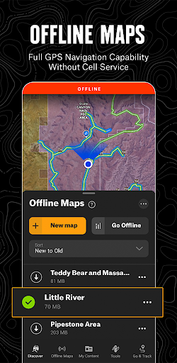
- Navigate confidently even without cell service by downloading custom maps for offline use. Your phone's GPS will guide you, showing your location on the trail so you can always find your way back.
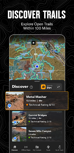
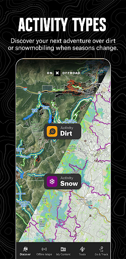
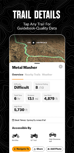
- Discover a vast network of over 615,000 miles of off-road trails, categorized for various vehicles including 4x4, SxS, dirt bikes, moto, ATV/Quads, Overland, and snowmobiles. Easily filter trails based on your specific needs.
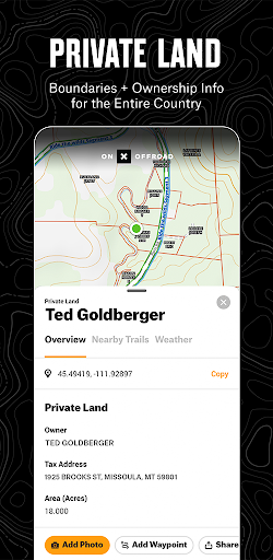
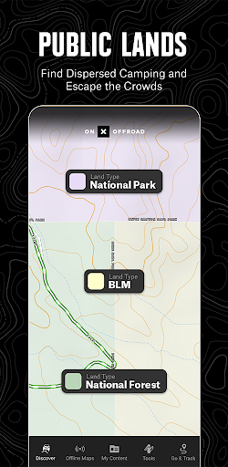
- Visualize your surroundings with detailed map layers. Access public land boundaries, recreation points, and even private property maps (Elite feature) to understand where you can legally ride and camp.
- Plan and share your adventures by dropping waypoints, recording your trips with speed and distance data, and leaving a digital breadcrumb trail. Share your routes with friends and family, or use it to retrace your steps.
Recent Improvements
Recent updates have focused on refining the offline map experience, ensuring greater reliability when you're deep in the backcountry. The team has also made strides in improving the accuracy and detail of public land data, making it even easier to identify legal access points. Performance enhancements mean smoother map rendering and quicker loading times, especially in areas with complex trail networks. Feedback regarding the clarity of trail designations has been incorporated, leading to more intuitive navigation.
FAQ
Can I use this app without a cell signal?
Absolutely! The onX Offroad app allows you to download maps for offline use. Once downloaded, your phone's internal GPS will function like a dedicated handheld GPS device, enabling you to navigate trails even when you're completely outside of cell coverage.
What types of off-road vehicles are supported?
The app supports a wide range of off-road vehicles, including 4x4s, Side-by-Sides (SxS), dirt bikes, motorcycles (moto), ATVs/Quads, Overlanding vehicles, and snowmobiles. You can filter the extensive trail database to find routes suitable for your specific vehicle.
How does the private property map feature work?
The Private Land Map Layer, available with an Elite subscription, displays nationwide private property boundaries and ownership information. This feature is crucial for understanding exactly where you can legally ride, camp, or access trails, preventing accidental trespassing.
Editor Security Review
Reviewed by the editorial team for
basic security, integrity, and package consistency checks.
- No known malware detected
- Signature verified
- File integrity checked
User reviews
This app is a game-changer for my off-roading trips! 🤩 Found so many new trails I never knew existed. Offline maps are a lifesaver too. Highly recommend!
Finally, an app that really gets off-roaders. The detail on public land and private property boundaries is incredible. Makes planning so much easier and safer. 💯
 ParkiMaps & Navigation
 MyTranslinkMaps & Navigation
 New Zealand Topo MapsMaps & Navigation
 13cabs - Ride with no surgeMaps & Navigation
 CabifyMaps & Navigation
 Careem – rides, food & moreMaps & Navigation
 CitymapperMaps & Navigation
 ChargePointMaps & Navigation
 Electrify AmericaMaps & Navigation
 MapQuest: Get DirectionsMaps & Navigation
 MarineTraffic - Ship TrackingMaps & Navigation
 네이버지도 (Naver Map)Maps & Navigation
 NJ TRANSIT Mobile AppMaps & Navigation
 ParkableMaps & Navigation
 Park ATXMaps & Navigation
 REVER - Motorcycle GPS & RidesMaps & Navigation
 Roadie DriverMaps & Navigation
 GPS EmulatorMaps & Navigation
 MyBluebirdMaps & Navigation
 Location ShareMaps & Navigation